


Zondres2d
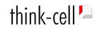
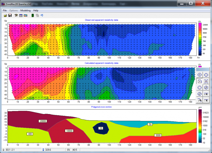
The Zondres2d program is designed for two-dimensional interpretation of electrical tomography data by resistivity and induced polarization method in land, cross-well and water cases. Electrical tomography (resistivity imaging) is a technique that includes both the method of field observations and processing technology and field resistivity and interpretation of IP data. Its characteristic is the multiple reuse as source and receiver only in the same position of the electrodes, fixed in a profile line.
Proveedor: Zond Software
SOLICITE UNA COTIZACIÓN
Descripción del producto
Basic characteristics:
- Both 32-bit and 64-bit versions are available.
- It supports any arrays of electrodes or combinations with arbitrary system of spacing and positions of electrodes. The possibility of working with different matrices (number of electrodes) in the same place.
- Measurements at the water surface and at the bottom of the water. Hole systems and cross holes. Any mixed system.
- Four ways to specify topography. Real-time editing. Strike parameter setting.
- Two ways of induced polarization reversal. Default scheme (static IP) and full waveform IP inversion for paste-paste parameters (time and frequency domain). Approximate and complete solution. Time-lapse inversion.
- Script recording for processing multiple files.
- Special options for large scale problems.
- Buffer for 5 models.
- IP data resistivity and quality control, data removal and editing module, EM removal .
- A set of tools for mathematical modeling of geoelectrical section. Standard mesh bitmap style, arbitrary layers model, and polygonal style model. Additional tools for direct gravitational, magnetic and self-potential modeling and joint inversion.
- Number of resistivity and IP inversion algorithms: smooth, focus, robust, block. Define the reference model for the inversion. Noise component suppression during inversion (robust reweighting).
- Suppression of static P/C displacements during inversion. Working with anomalous MAN AMNA matrices (method of true anomalies).
- Definition of limits for model parameters, insertion of a priori geological limits and data of holes for inversion. Assigning weights to data records. Measurement editor.
- Estimation of the quality of results based on sensitivity matrix analysis. Calculation of sensitivity, quality and DOI index .
- Crop of model edges: by angle or sensitivity level.
- Number of variants for data visualization, model and a priori information. Ability to define a semi-transparent background for the resistivity section (geological and seismic sections).
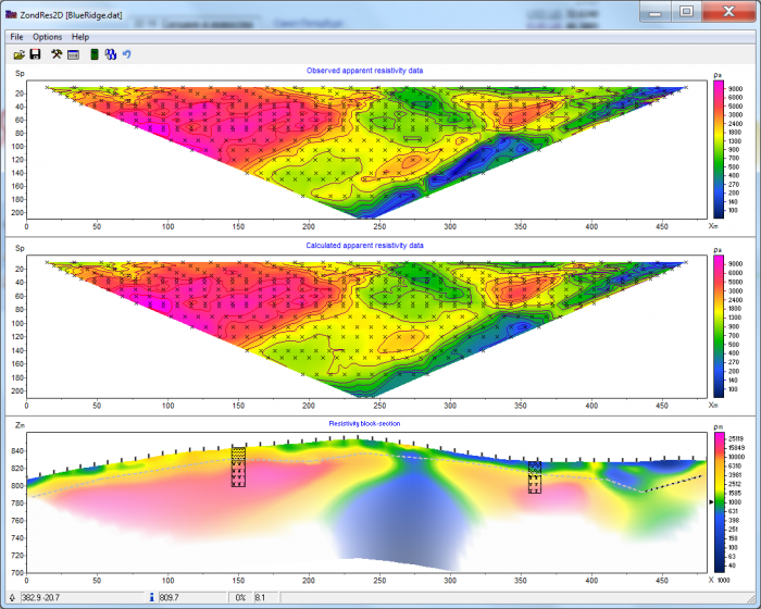
- Three-dimensional visualization of geoelectric sections along arbitrary system profiles. Maps parameter slices to various depths.
- Geological section editor and well column editor. Titled holes.
- 2D joint inversion with magnetotelluric, refractive seismic and TDEM data.
- Support for the MMR method
- Export to bitmap and vector graphics formats, excel, surfer, AUTOCAD. Set the scale of the exported image. Print images and create reports.
¡Gracias! ¡Nos pondremos en contacto con usted pronto!
Baixe o Guia Software.com.br 2024

nuestros clientes